
Weston Ranch Crossings
 The City of Stockton received a federal grant to increase safety for pedestrians and bicyclists at nine (9) crossing locations in Weston Ranch.
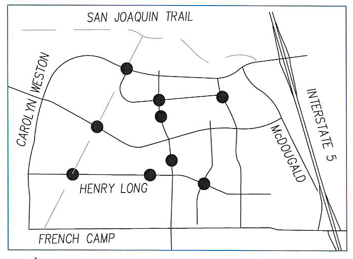
Each crossing location was studied and recommendations for improvements included combinations of flashing beacons, high visibility crosswalks, signage, curb ramps and other changes along the curbs, gutters and sidewalks, depending on traffic and pedestrian needs at each crossing.
All improvements were made within the City's existing right-of-way.
Crossing Locations
- Henry Long Blvd. at San Joaquin Trail - Nearest cross-street Estes Ave and east of George Komure Elementary
- William Moss Blvd. at San Joaquin Trail - Nearest cross-street Sacchetti Circle
- Carolyn Weston Blvd. at San Joaquin Trail - Nearest cross-street Ishi Goto St.
- Ews Woods Blvd. at Boardwalk Drive
- Ishi Goto St. at Ews Woods Blvd.
- Ews Woods Blvd. at Little Hale Place - August Knodt Elementary
- Henry Long Blvd. at Venice Circle - North side of Weston Ranch High School
- Henry Long Blvd. at Star Way - Great Valley Elementary
- McDougald Blvd. at San Joaquin Trail - Nearest cross street Ishi Goto St.
Project Status
A public meeting was held in June 2018. Representatives from the City of Stockton Public Works Department and members of the design team discussed proposed plans. Members of the community reviewed project plans and maps and provided input to the design process.
- Preliminary designs were completed in September 2018.
- Final plans were completed in August 2019.
- City Council approved project design and construction in February 2020.
- Installation began in April 2020.
- All improvements are installed and the project was completed in September 2020.
For information, please Contact Us.
External Links
There are currently no external links.
This City of Stockton web page last reviewed on --- 10/16/2020