
State Flood Information
200-Year Floodplain Building Requirements
The State of California Central Valley Flood Protection Act of 2008, commonly referred to as SB 5, adds additional flood risk considerations for land use planning and sets a higher, 200-year level of flood protection for the Sacramento-San Joaquin Valley. Cities and counties within this region were required to amend General Plans and adopt zoning and building code regulations to provide for this "urban level of flood protection."
A 200-year flood event statistically occurs on average once every 200 years or has a 0.5 percent chance of occurring in any given year. A 200-year floodplain map has been developed for the Stockton area showing anticipated depth of flooding throughout the Stockton metropolitan area. This map includes a significant portion of the western side of the City near I-5 and some areas in the central and eastern side of the City that would experience flooding during a 200-year flood event. A link to the 200-year flood map can be found under External Links at the bottom of this page.
Changes Adopted
The City of Stockton adopted changes to its General Plan in June 2015. Building and zoning code changes apply to all permits issued after July 2, 2016. These changes include:
- increased building setbacks for flood fighting along levees,
- requirements to elevate buildings above the floodplain or use flood-resistant building materials for development in areas identified as flood hazard zones on federal flood maps, and
- streamlining the process of making specific findings for development of residential and commercial land uses.
A "finding" is a conclusion based on facts and commonly required to support the decision to approve a land-use permit. Before an affected project can be approved, findings must be made that the proposal meets the new state flood protection requirements.
Findings will be made for the following:
- Construction of all new residential structures,
- Discretionary permit or other discretionary entitlement with construction of a new building or construction that increases allowed occupancy for an existing building,
- New development agreements for all types of property development,
- Tentative maps consistent with the Subdivision Map Act for all subdivisions, and
- Parcel maps for which a tentative parcel map is not required, consistent with the Subdivision Act.
Residential Uses
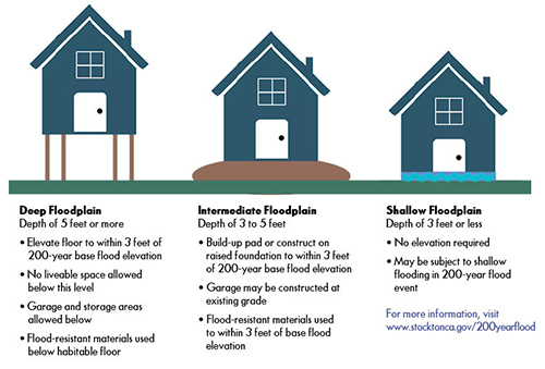
All new residential structures will require findings for 200-year flood protection. The illustration below shows regulations that apply to residential structures built in deep floodplains (red on the map), intermediate-depth floodplains (yellow/orange), and shallow floodplains (blue):
These regulations do not apply to existing residential structures or where structures are being replaced due to fire or damage.
Commercial Uses
Certain prior commercial discretionary uses are now considered "by-right" uses and will not require SB 5 findings. This means many commercial land-use projects consistent with the applicable zoning district will only need ministerial site plan and design review.
Findings may be required for non-residential projects subject to discretionary permits that result in an increase in the allowed occupancy of an existing building. In some cases, buildings may need to be flood-proofed or constructed on raised foundations to meet this requirement.
Development Criteria
The Community Development Director is authorized by the Stockton Municipal Code to establish criteria for development in 200-year floodplains. The criteria in the link below outlines the different requirements for development projects including Residential, Non-Residential, Subdivisions, and Accessory Dwelling Units.
Flood Risk Requirements
To determine the flood risk for your property and/or use, please Contact Us at the Building & Life Safety Division. Additional information is available in the Stockton Municipal Code (SMC) for:
- Section 15.44.040 – Definitions
- Section 15.44.135 – Allowable Land Uses and Permit Requirements
- Section 16.20-020, Table 2-2 – Allowable Land Uses and Permit Requirements
- Section 16.36.110 – Setback Reulations and Exceptions
- Section 16.90 Floodplain Management Findings (200-year flood protection)
These regulations are separate and in addition to those required under the Federal Emergency Management Agency (FEMA) flood regulations and do not trigger a requirement for flood insurance. For more information about 100-year Federal flood zone requirements, please visit the Federal Flood Information webpage.
External Links
200-Year Flood Map - Maintained by San Joaquin County Public Works
This City of Stockton web page last reviewed on --- 10/29/2019